N7SMI High Altitude Balloon
Tracking Map
Position updates occur at most every 10 minutes when the balloon is in daylight.
Telemetry
Last heard: 7 years ago
Altitude: 29,425 feet
Lat/Lon: 27.62500 -104.16667
Speed: 18 miles per hour
Voltage: 4.1 volts
Reported by: VE6JY (1856 miles away), AA7NM (1655 miles away), K9AN (1301 miles away), K4COD (1286 miles away), N7SMI (1025 miles away)
Current Flight
Flight Details
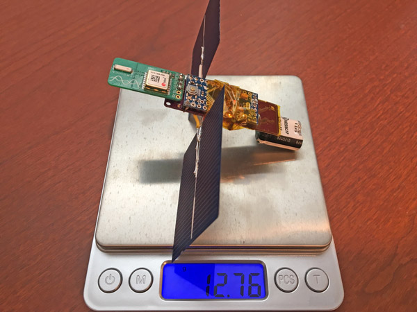
This flight utilizes a newly designed solar charge controller and transmitter board, and also is flying on new, (hopefully) more reliable balloons. Larger solar cells are onboard to account for less Northern Hemisphere sunlight late in the year. Total payload weight is 14 grams - the weight of 2.5 US quarters.
Day One - October 28th
Launch
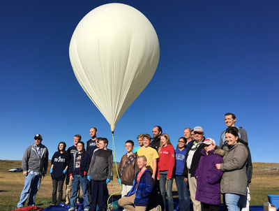 Launch from Southern Idaho went very smoothly - almost no breeze. Unfortunately the intermittent transmission problem from last flight has not been resolved. I need to do more debugging!
I also helped launch a balloon for the Cache Makers 4-H youth group that my son is a part of. CMAKER-5 went to over 126,000 feet! The payload landed in a tree in someone's front yard, but we were able to recover it.
Float
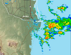
The balloon entered a float at just under 30,000 feet. I had anticipated a higher float altitude. It travelled 240 miles before sunset. Despite the intermittent transmissions, there were 604 WSPR reception reports - the most distant being PY2GN near Sao Paulo, Brazil - 6000 miles away!
Day Two - October 29th
The balloon woke up over Flagstaff, Arizona having travelled 300 miles over night. It maintained 30,000 feet altitude and moved slowly South travelling only 125 miles during the day. Predictions show that it will take a slow left hand turn to the East and will pick up speed in the coming days (if it survives). It's travelled 630 miles total. There were 873 WSPR reception reports today, the most distant being WA9WTK 2217 miles away in Massachusetts.
Day Three - October 30th
It's gone international! It woke up in Northern Mexico. It travelled 320 miles last night and another 300 miles throughout the day. Total distance travelled is over 1200 miles. There were 571 reception reports today (not too many beam antennas pointed toward Mexico, I guess), the most distant again being WA9TWK at 2141 miles in MA. Many of the transmissions were picked up at my home station over 1000 miles away.
Day Four - October 31st
 Nothing was heard from the balloon today. There were very large storms in the Gulf of Mexico where the balloon should have been in the morning. 30,000 feet is not high enough to avoid these. Any moisture or icing on the balloon will bring it down. I'll make adjustments to try to get my next balloon higher and will try again soon.
Project Details
Overview
This High Altitude Balloon (HAB) project is intended to expand my programming and hardware skills to see how far I can get a high altitude balloon transmitter to float at over 30,000 feet. The tiny payload weighs only 14 grams and fits in the palm of my hand. It floats below two 36" mylar balloons. Total cost per flight is <$60.
Hardware
 The payload is comprised of:
- Arduino Pro Mini microcontroller
This tiny $10 computer is the brains of the payload. - 2 X solar cells
The very thin, lightweight solar cells generate 1 volt. - N7SMI PicoHAB board - solar charge controller and transmitter
This PCB is of my own design and optimizes the solar power to charge a 5 volt supercapacitor. Batteries are heavy and do not work at 40 below zero at 30,000 feet. Being solar powered, transmissions will only happen during the daylight. The board also houses a Si5351a transmitter. Two 10 milliwatt WSPR (a very low power, HF mode) transmissions are made on the 20 meter amateur radio band every 10 minutes. The first transmission includes my call sign (N7SMI), rough location (within ~100 miles), and signal strength. The second includes telemetry - altitude, more precise location (within a few miles), and solar voltage. 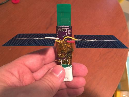 GPS module
A GPS is used to capture altitude, latitude, and longitude- Dipole antenna
A quarter wavelength vertical dipole antenna (404 inches long) is constructed out of VERY thin 36 gauge magnet wire. The entire antenna weighs 1.5 grams - about the weight of a paper clip.
Details about the payload are available at Google Docs.